Regional Mapping of Groundwater Resources in Data-Scarce Regions: The Case of Laos
by Mathieu Viossanges, Paul Pavelic, Lisa-Maria Rebelo, Guillaume Lacombe, Touleelor Sotoukee
Abstract
This study focuses on Laos, a landlocked nation located in South-East Asia with sub-tropical climate and highly seasonal rainfall distribution. Laos is one of the world’s least developed countries, and currently witnesses an unprecedented level of development that is highly reliant on its natural resources, including groundwater. There is currently very limited data and no nationwide assessment of shallow (<30 m) groundwater resources to support sustainable management. This study provides a first step towards addressing this issue by
- (i) identifying the major aquifer units of the country;
- (ii) integrating localized data and regional maps into an assessment of the groundwater potential; and
- (iii) producing quantitative maps of key hydrogeological indicators.
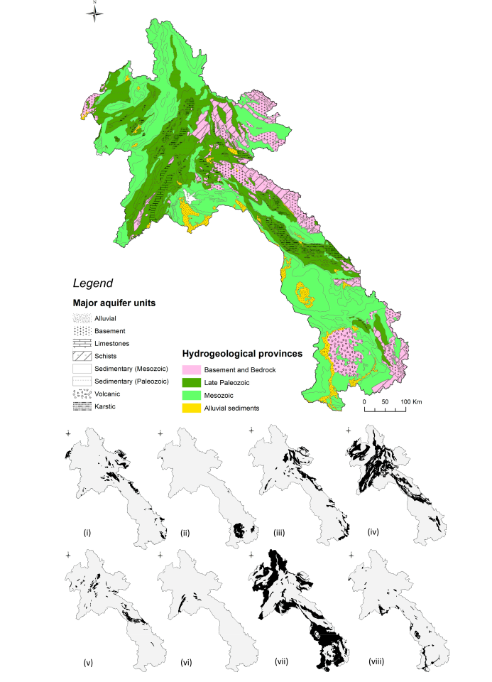
Eight aquifer units have been described and evaluated:
- (i) Basement aquifers,
- (ii) Volcanic aquifers,
- (iii) Schists,
- (iv) Paleozoic sedimentary,
- (v) Karsts,
- (vi) Limestones,
- (vii) Mesozoic sedimentary and
- (viii) Alluvial sediments.
The Mesozoic sandstones and the Alluvial aquifers are the most extensive and productive hydrogeological systems in the country. The Volcanic and Karstic aquifers, although poorly known, might also have important potential. This assessment, along with the maps of quantitative aquifer indicators, provide a significant improvement in both spatial resolution and accuracy compared to previously available information. It will likely support improved management plans and the identification of areas with higher potential for groundwater development.
Definitions
Aquifer
An aquifer is a body of rock and/or sediment that holds groundwater. Groundwater is the word used to describe precipitation that has infiltrated the soil beyond the surface and collected in empty spaces underground. (Source)
There are two general types of aquifers: confined and unconfined. Confined aquifers have a layer of impenetrable rock or clay above them, while unconfined aquifers lie below a permeable layer of soil.
Borewell
Borewells are human-made wells dug deep into the ground to tap into water-bearing soil, or rock layers termed aquifers. (Source)
Lithology
The study of the general physical characteristics of rocks. (Oxford dictionnary)
Preliminary information
General relevant information on Laos
- 80% of the rain falls between May and October
- During the wet season, precipitations ranges from 1300mm to 3700mm
- The Mekong flows from the North to the South
- Mountains are in the north and south toward Vietnam
- Low land are in the south from Vientiane
The possible groundwater development are in the areas of:
- Hydro-power
- Agriculture
- Industry
- Domestic needs
Other general relevant information
What are the interesting characteristics of an aquifer?
The study
The study aimed at gathering informations and datasets to answer the question:
What are the major aquifer units of Laos, their spatial distribution and their development potential?
More precisely by analysing the three important characteristics of an aquifer:
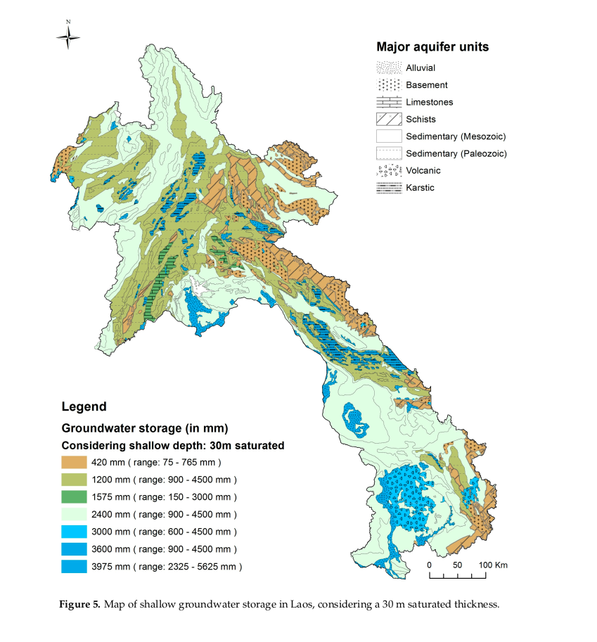
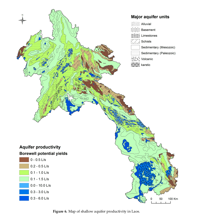
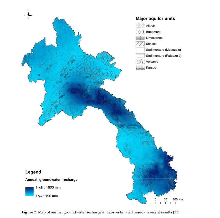
- Storage capacity
- Productivity
- Recharge rate
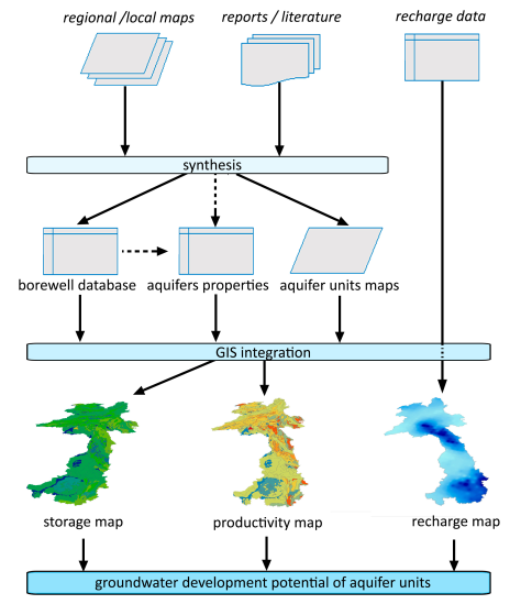
Sources of data were:
- regional and local maps
- reports/literature
The following schema represents the process from the data to the output:
Results
Spatial distribution
First result it to map the 8 types of aquifers.
Characteristics
Then we can map the results for each of there important characteritics.